Saturday, September 15, 2012

RAMBLING SOME MORE IN ÖLAND AND THE GLASS DISTRICT

TUESDAY, AUGUST 14, 2012—Öland and the “Glass District”
We continued our exploration of Öland by driving north to the northwest side of the island to see Byrums raukar Nature Reserve.  There are about 120 limestone columns in the reserve, which formed when waves eroded softer limestone away.  The tallest columns are about 13 feet high and come in various shapes.  They are very unique and reminded me of the “pancake” rocks I had seen in New Zealand.  A limestone cliff rises above the columns and vegetation is very sparse in the area.  I dipped a hand into the water of the Baltic Sea while walking among the columns—I couldn’t resist the opportunity.  Mother Nature does some amazing things on planet Earth!

Byrums raukar Nature Reserve
We then headed south along the west coast of Öland to Borgholms Slott, which is northern Europe’s largest castle ruin.  It is one of the first castles built by a Swedish monarch and is first mentioned in 1281.  The castle sits on a cliff overlooking a strait so it was primarily a defensive observation post.  Historically, the castle has been under German and Danish control in addition to Swedish control.  The castle sustained heavy damage during the Kalmar War of 1611-1613 between Sweden and Denmark.  It was abandoned in the 18th century and in 1806, the remains were devastated by fire.  Preservation work began in the 1880’s and continues to this day.  The castle is an imposing structure and I am glad they have been able to preserve this part of the country’s history.
Borgholms Slott
We continued our leisurely drive down the west coast through small towns, past a large marina, and past numerous farms with characteristic narrow fields running in an east/west direction.
Typical stone fences on the island
I saw quite a few RVs on the island, mostly small motorhomes (translates to “house cars” in Swedish) and trailers.  It really is a beautiful island with a tremendous variety of things to see in such a small area!  It was easy to see why Mari-Anne likes the area so much; I could have easily spent several more days exploring the island if it wasn’t for my “schedule”.  However, we had more miles to cover and more sights to see before returning to Jakobsberg so we crossed the bridge back to the mainland at Kalmar where we had a nice lunch at an outdoor restaurant.
After lunch, we headed west to Nybro, Boda, and into the heart of the Glasriket aka the Swedish “Kingdom of Crystal” in southeast Sweden.  We took numerous small backcountry roads through the area and northward towards Stockholm.  The land in the Glass District was heavily forested and opened up into rolling farmland interspersed with forestland as we drove north out of the district.  We visited four glass factories in the afternoon and watched glass blowers work at two of them.  One establishment had a very interesting glass exhibit with beautiful pieces on display.  The glass blowers and designers are truly “artists” in every sense of the word and I saw many stunningly gorgeous pieces—with prices to match at the locations we visited.  (Yes, I bought a couple of small pieces.)


Glass blowers in the Glasriket
Glass Exhibit--absolutely stunning!
I could have spent considerably more time in this area, too; however, the hours were passing rapidly and we had many miles to drive before getting back to Jakobsberg.  Therefore, we headed north and arrived home at 2245, thus ending another delightful day and a wonderful visit to southeastern Sweden.  This area really was very different from the northern and western parts of the country that I had seen previously.  Unfortunately, my time in Sweden was swiftly coming to a close—much too quickly.

FAST FACTS:  There are at least 11 glass factories in the Glass District, which is Sweden’s third largest draw for tourists after Stockholm and Göteborg.  Glass work in the area began in Kosta in 1742.
Although I cannot find the source of the information as I write this, somewhere in my reference material I read that many of the early Swedish emigrants to the U.S. came from the areas we traveled in the past two days.

Tuesday, September 11, 2012

ÖLAND

MONDAY, AUGUST 13, 2012—Öland
Mari-Anne and I were up early, out the door, and headed in the car for Öland, a long (85 miles), narrow (9 miles) island off the southeast coast of Sweden and known as a summer get-away location.  Enroute, we bypassed Stockholm by taking a ferry to the west of town, and then passed old manufacturing towns, seaports, rolling farmland, and lots of forested land.  We stopped for a break along a canal in Söderköping, found a geocache (that I have failed to log), and strolled through some of the town to stretch our legs.  The buildings were old and many streets were quite narrow as were the sidewalks, but the town really was charming.  I would have liked to explore more, but we had many more miles and things to see this day.
Canal in Söderköping
Apartments made out of 4 silos in background (Söderköping)
The area became less populated as we drove south to Kalmar where we turned east to take the bridge to Öland.  We stopped immediately on arrival on the island for a late lunch; I had some kind of a shrimp salad sandwich.  I like shrimp but I didn’t particularly care for some of the other ingredients they put on the piece of hard bread.  Oh, well, there was a lot of shrimp and a couple of tomato slices, so my hunger was satisfied.  It was certainly a different dish than what I thought I was getting, though.
Shrimp Salad Sandwich
After lunch, we headed south along the west shore of the island.  This was definitely farming country with many farms along the way.  The soil is rich except on the Alvaret plateau, which runs roughly down the center of the island where the limestone bedrock comes to within a couple of inches of the surface or right to the surface.  I saw very little grazing on the plateau because of the lack of vegetation—it reminded me of New Mexico with the current drought conditions.  However, as soon as we drove away from the plateau, the farmland was lush with a variety of crops under cultivation.  It was late in the summer, so some harvesting of small grain was underway.  Some of the crops observed included corn, onions, beans, carrots, wheat, and alfalfa.  I also saw hogs, cattle (especially dairy cattle), sheep, and chickens on farms.  Farm buildings were generally very old, close together, and were usually built in a square to provide a windbreak.
Typical Öland farm
 I saw John Deere farm equipment all around the island—there were a few other brands from other countries there, too.  However, it looked as though JD had a good foothold on the market.  There were quite a number of wind farms on the island and I saw some offshore, too.  They are definitely putting their naturally occurring wind resources to good use.
Village street
   

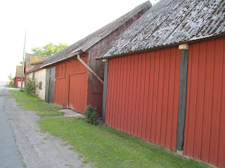
Öland farm buildings

Same group of farm buildings but extending in opposite direction 
Farm house and outbuildings
 We traveled to the south tip of the island, which is a nature preserve and world-class birding site.  Unfortunately, the visitor center had closed by the time we arrived, but we did visit with some birders out on the shoreline and looked at a sea eagle through a spotting scope.  An operating lighthouse adorns the very tip of the island.
Öland lighthouse
We turned northward along the eastern shore of Öland and before long we passed by “King Karl’s wall” for the second time.  King Karl X Gustav ordered farmers to build the wall in 1653 to keep deer a previous king had imported, and which multiplied mightily, from eating farmers’ crops.  The wall is about 15,200 feet long running east/west from shore to shore.  The wall did not deter the deer as they continued to leap over it.  The limestone wall was protected by law and was in quite good condition in the areas we saw.
"King Karl's Wall"
Our next stop was the Eketorp ring fort originally constructed about 400 AD during the Iron Age.  The fortress was enlarged and reconstructed during the Middle Ages and was in and out of use for periods over the centuries.  It was late in the day when we arrived and everyone was gone; however, the gate was open so we went in and viewed the interesting exhibits from different periods of the fort’s history.  It never ceases to amaze me when I look at centuries-old buildings how well constructed they are.  Even though this fort has been reconstructed in some areas, the fact remains that the basic structure is truly awesome.
Eketorp Ring Fort
We continued northbound from Eketorp, crossing the island a couple of times so I could get a good feel for the Alvaret.  We saw many farms along the way when off the Alvaret, passed through some small towns, and drove past several ancient (500-1,000 AD) burial grounds. 
Ancient burial grounds along the road
We also saw quite a few thatched roofs on old buildings as well as numerous wooden windmills, which are not in use.  Roughly, the south half of the island is a UNESCO World Heritage Site so the area is preserved much like it was in centuries past. 

Some of the approximately 400 old windmills on Öland
We stopped at one well-preserved linear village open-air museum, which was closed for the day.  It was interesting to walk around and see how the farm buildings were arranged as wind breaks as well as how they were constructed 200-300 years ago. 


Himmelsberga Museum--Öland
Darkness was approaching fast and, since we couldn’t find anywhere to eat along the way, we had dinner consisting of hot tea and the snacks we brought along in our hostel building lobby.  Not elegant--but good!  We spent the night in Köpingsvik, on the west shore about midway between the north and south end of the island.
Dinner on Öland
I cannot begin to elaborate on all that I saw this day.  It was really mind-boggling from the modern cities, to iron-age relics and graves, to modern farms using centuries-old buildings and stone fences along with modern farm implements.  We passed dozens of very old windmills no longer in use to grind grain along with new wind turbines providing electricity to Sweden and probably other countries, too, on the international grid system in use in this part of the world.  However, one of the neatest things observed this day was the delight in Mari-Anne’s demeanor and voice when we got to the island.  Öland is an area of the country that she clearly feels comfortable in and loves!
FAST FACTS:  Biogas is made in small refineries in different locations—we had to search out fuel stations that carried it.  In Uppsala, it is only sold to residents holding a special card to activate the pumps since only enough is made to service residents.  Biogas is made from garbage in Sweden.
What we call “gingerbread” on a house in the U.S. is termed “carpenter’s happiness” in Sweden.

Sunday, September 9, 2012

VASA MUSEUM AND GRISSLEHAMN

SATURDAY, AUGUST 11, 2012—Vasa Museum
We stayed around home this morning to regroup.  Then, in the early afternoon, Mari-Anne and I took the train into Stockholm and went to the Vasa Museum—one of the “must see” museums in Stockholm.  And I wasn’t disappointed!
Sweden was embroiled in an ongoing war with Poland in 1628.  In 1625, the Swedish King, Gustavus II Adolphus, ordered a “Royal Ship” built, the 17th century designation for the largest type of naval vessel.  Construction began in 1626 and 1,000 oak trees were felled for the ship.  The ship named “Vasa” was to be the most powerful warship in the world.  Vasa’s maiden voyage from Stockholm harbor took place on August 10, 1628, and it sailed approximately 4,300 feet before capsizing after it was hit by a slight gust of wind.  The ship had masts more than 50 meters (165 feet) high, 10 sails, 64 large guns, and hundreds of gilded and painted sculptures.  Decorative artwork on the Vasa included 500 figure sculptures and over 200 carved ornaments.  The hull length was 156 feet while the maximum width was 38 ½ feet.  The draft was 15.8 feet—not much for a ship of this size, in my estimation.  It was outfitted to carry ballast and ammunition in addition to 145 crewmembers, 300 soldiers (not on board) and supplies.  Family members of the crew were on board for the inaugural sailing.  Approximately 50 people went down with the ship.

1:10 Scale Model of VASA


Exhibit Showing Life Aboard VASA
Over the years, numerous searches for Vasa came up empty until 1956 when it was located.  Salvage efforts began almost immediately and she was raised to the surface in April 1961.  Although the restoration work has been awesome, even more remarkable in my mind is that 95% of the ship is original!  The preservationists have been careful to leave the repairs in a “raw” state instead of making them blend in with the rest of the ship, thereby making it easy to see what parts of the ship have been restored.  One of the intangible benefits of finding Vasa in such good condition and being able to successfully salvage her, is that it gives immense insight into life for seafaring men during the 17th century.  The ship’s furnishings were in remarkably good condition and 14,000 archaeological finds were registered in five months of onboard excavation.

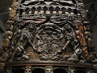
The VASA
All too soon, it was time for the museum to close and we made our way back to Jakobsberg, arriving about 2000.  Gunnar said the next-door neighbors would be over about 2030 for coffee, so we ate a quick dinner.  The neighbors arrived as planned and I was delighted to see Sven Erik again and meet his wife, Britt.  They had lent us the use of their condo in Åre and we spent the rest of the evening reminiscing about our trip there.  We also had an interesting discussion of some of the social differences between Sweden and the U.S.  Overall, it was another day full of “discoveries” and interesting conversations.
FAST FACTS:  In Sweden, 16 months of parental leave is granted after a child is born, which continues through age seven.  Both parents are expected to share the leave; however, fathers must take a minimum of 60 days or forfeiture requirements kick in.  The government reimburses the parents for a portion of salaries lost during this time (80% for most people) and the parents do not have to be married to qualify for the leave.  The rules are quite complicated, but this explains the policy briefly.  Incidentally, I found out while researching this fact, that the U.S. is one of four nations without a national parental leave law.  The others are Liberia, Papua New Guinea and Swaziland.
SUNDAY, AUGUST 12, 2012—Grisslehamn
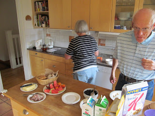
We were up early, ate another of the Mari-Anne and Gunnar’s traditional bountiful breakfasts (some of which I have adopted, I liked it so much), and got in the car for the 90-minute drive to Grisslehamn, a small community northeast of Stockholm right on the Baltic Sea coast. 

Breakfast at the Stignäs Home
It was a very pleasant drive to the Stignäs’ summer home, which I found, was near summer homes owned by their children.  The families spend quite a lot of time there during the summer and the grandchildren have wonderful opportunities to enjoy each other as well as having quality time with their grandparents.  I really enjoyed meeting Mari-Anne and Gunnar’s children and grandchildren (all but two older grandsons).  This was important to me because now I can put faces with names when I read about them in Mari-Anne’s emails or on various Facebook posts.  It was also very nice to see their summer homes for the same reasons.  The location along the coast is idyllic and I can certainly see why they like to spend as much time as possible there!
Grisslehamn Summer Home

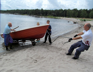
 Mari-Anne and I took a short walk around the surrounding area to see two of the children’s places, neighbors’ places, secluded coastline areas, etc.  When we returned, some of the family was busy taking a boat out of the water—it was time to put it away for the winter.
Time to put the boat away for the winter!
After closing up the home, we went into town where we had some very good fish soup at water’s edge.  This was topped off with an ice cream cone after bagging a geocache (what else?), followed by a short hike.  Too soon, it seemed, it was time to head back to Jakobsberg.  Mari-Anne prepared the fresh cod she had bought in Grisslehamn for dinner that night which was delicious.  I have eaten a lot of cod through the years and have always liked it; however, this was out of this world!  This drew to close a very nice day with the Stignäs family.
FAST FACTS: As with other European countries, people in Sweden have generous vacation leave (by U.S. standards), which they tend to use.

Sunday, September 2, 2012

NORTH TO ÅRE


WEDNESDAY, AUGUST 8, 2012--Åre
Gunnar, Mari-Anne, and I were up early and out the door at 0625 to meet a neighbor who drove us to the train station.  We caught the train to Stockholm Central Station, then transferred to a train that took us to Åre (pronounced Orrra) in northwest Sweden.  The total trip time was about 7.5 hours and it was a great way to travel to the north country.  Initially, we followed much the same route to Gävle that we had driven southbound from our trip to Dalarnas during my first week in Sweden.  From Gävle it was all new country to me.  The farther north we went, the more it changed from the urban, rolling farmlands of the south.  More houses were painted the traditional red color that the barns and other outbuildings have all over Sweden.
Swedish Farm
A few homes were painted yellow, which seems to be a “favorite other color” for homes in Sweden.  The farms were quite small by U.S. standards and were mixed with timber and some logging as we went north.  From Bolnäs, midway through our 300-mile trip north followed by another 50 miles in a westerly direction, we followed water in the form of lakes and rivers nearly the whole way.  In addition--the country became more and more rugged.  We couldn’t tell it on the train, but we were climbing as we went north.  It really was a beautiful trip through this part of the country!  Logging seemed to become “king” as we went north because we saw more and more evidence of it.  Sawmills, paper mills and piles of logs being loaded and unloaded were a common sight.  I also noticed quite a bit of “clear cutting” being done in the north country, so I guess that method of harvesting timber has come to Sweden, too.  Gunnar told me that logging has become quite mechanized resulting in a loss of jobs in the northland with people moving elsewhere to find work.
Oh, and I must mention our food on the trip.  Mari-Anne had brought along coffee and tea as well as snacks for a mid-morning snack.  Then, midway through the trip, Mari-Anne and Gunnar broke out the lunch--I am sure we had the best lunch on the whole train!  Complete with a tablecloth, no less!  It was delicious!
Lunch on the Train
We turned west at Östersund to traverse the final 50 miles to Åre along a river and a long narrow lake in the bottom of a narrow, forested valley.  Yes, it really made me feel like I was back in the mountains!  We arrived in Åre at 1425, picked up the rental car and some groceries, and headed to the condo that the gentleman/neighbor who provided us the ride to the station this morning was letting us use for our stay.  This is a beautiful location high up on the mountainside overlooking the valley with its lake running through it.  After dropping our bags and groceries off at the condominium, we drove into town and took a short walk around to stretch our legs a bit.
Åre
It is a charming town located in a major downhill skiing area, reminding me of some of the smaller ski resort towns in the Rocky Mountains.  One source lists Åre as the largest ski resort area in Sweden and in 2009, Condé Nast Traveller named it winner of “World’s top ski resorts”.  There are also quite a few long cross-country hiking trails up in this part of Sweden and I saw several backpackers in town.
We returned to the condo after checking out the town and surrounding area.  Gunnar and Mari-Anne prepared a wonderful dinner of boiled potatoes and a skillet casserole dish with reindeer meat, vegetables, onion, and cream.  They also served Lingonberry jam (a staple in Scandinavian cuisine)—just a little used with each bite of potato and the casserole.  Ice cream and a chocolate mint from the local chocolate factory finished off the meal. 
"Chef" Gunnar

Ready for dinner in Åre
After dinner, I helped Gunnar set up a geocaching account on his cell phone.  A lively and interesting discussion of world politics (one of several such discussions we had) topped off the evening.  This brought to end a long day filled with new sights and experiences.

FAST FACTS:  The elevation at Åre is approximately 4700MSL.  Snow was in the mountains not very high above town and the tree line appeared to be about 5000MSL.  Temperatures were definitely cooler than in the Stockholm area that is at or near sea level.  Åre is about halfway between 63°N and 64°N.
Very large parking lots for bicycles surround the train station in Uppsala.  I would estimate there were easily several thousand bikes left there for the day by commuters.  It seems nearly everyone rides a bike in Sweden; it is as normal as walking to your mailbox outside your house in the U.S.  In addition, people of all ages use this mode of transportation.  I didn’t see many motor scooters in either Norway or Sweden, but I did see quite a few motorcycles in Sweden (mostly Harley Davidsons).
 
Bicycle parking at Uppsala Train Station

THURSDAY, AUGUST 9, 2012—Åre
We had a leisurely breakfast before heading out to explore the Åre area.  Our first stop was Åreskutan Mountain (elevation 4656 ft. MSL) where we rode the tram most of the way up the mountain.  We were above tree line shortly after we ascended from the tram station and we went into clouds just before reaching the upper station that is located just below the mountain’s summit.  (Snowmobiles take skiers to the summit.)  Patches of snow were around the higher areas and the temperature was -2°C with a blustery wind blowing when we got off the tram.  This was quite a change from the 100°+ F temperatures I had left in South Dakota—and which they were still having!  We took the next tram back down the mountain and the skies were beginning to clear while we descended.  The weather was promising to be a beautiful day in the mountains.
Åreskutan Mountain


Looking west from Åre
We next drove to Tännforsen waterfall a few miles west of Åre.  Tännforsen is one of Sweden’s largest unspoiled waterfalls, formed on a steep edge of a jutting section of slate bedrock.  Special growing conditions exist here because of the near continuous existence of mist resulting in rare and interesting lichen on the slate rocks and trees around the falls.  I saw numerous types of lichen that were the largest I have ever seen and I had no idea of all the various types of lichen that grow here.  I am a lichen “watcher” when I hike because it is a good indicator of the air quality in an area; however, the varieties I saw in this area were really mindboggling!  The park’s observation platform at the falls really takes you “up close and personal” to the roaring falls—and did they roar!  There was no way that you could talk while on the platform because of the noise.  This part of Sweden, as with Norway, had an abundance of moisture this year so the falls were really putting on a show for us.

Above Tännforsen waterfall


Tännforsen waterfall
Before leaving Tännforsen, we decided to have lunch.  I had trout with a delicious dill sauce; we also had Swedish waffles with cloudberry jam for dessert.  The waffles are thin by U.S. standards and are very light and fluffy.  Cloudberries come from north of the Arctic Circle and the jam was very tasty.  It is quite sweet with small seeds in it similar to seeds found in raspberries.  All in all, this was a superb lunch!

Our final stop this day was at Njarka Sameläger (aka Njarka Sami Camp), a living open-air museum operated by a Sami woman and her husband.  We arrived in time for the 3 o’clock tour but, instead of staying for the normal one hour, we didn’t leave until 1745!  We were the only customers for the tour and since we seemed very interested in hearing what the woman had to say, she spent extra time explaining the Sami culture, political issues, lifestyle, etc., in addition to answering our myriad questions.  After giving us a very complete tour of the camp, including new huts under construction, she invited us into one of the teepee-style dwellings at the camp and gave us coffee prepared over an open fire to drink while she prepared bread for us.  The bread was cooked in a cast iron skillet and was good.  We sat on the ground on reindeer hides and listened to stories she told us of Sami life and of the struggles they are having in today’s political system.  She said she has encouraged her children to leave the Sami camp and get jobs elsewhere because their lives will be easier than if they live the traditional nomadic Sami lifestyle of raising reindeer.  They have lost much of their traditional grazing land over the years to large hotels moving in and buying up vast quantities of land for guests that come to hunt.  Other land has been bought up by different business and political entities with the end result being that reindeer herds have dwindled due to lack of grazing land availability.  She said that some Navajo Indians from the U.S. had been in the day before and their stories were very similar to what the Sami have experienced.  As we were talking, I was thinking of all the Native American villages and lands I have visited through the years, and the striking similarities between what the Sami are going through now and what the Native Americans have gone through.  The woman was very passionate and, as I told Mari-Anne, she really had that “fire in her belly” when it came to sharing her story with us.  All three of us came away with a much better understanding of the Sami culture and the problems they face today and beyond.  We talked about her many times that day and in the days that followed.  To say that she made an impression on us is an understatement!
Njarka Sami Camp


Sami "backpack"
 
Traditional Sami footware
 
Feeding reindeer

Coffee and conversation time in the Sami dwelling
Our Hostess making bread for us

Bread cooking over open fire (thanks for the pic, Mari-Anne)
FAST FACTS:  The Sami are indigenous to the Scandinavian Arctic with lands in Norway, Sweden, Finland, and the Kola Peninsula in Russia.  The region where they live is usually called Sápmi, but sometimes Samiland.  They have their own culture, language, traditions, and, since 1986, their own flag.  There are approximately 20,000 Sami in 51 communities in Sweden.
Reindeer play a key part in Sami culture providing them with food and leather.  The antlers are used to make knife handles and jewelry.  Not all Sami are reindeer farmers as commonly believed; historically, they have made a living from fishing and other activities.  Today, they are involved in tourism, clothes design, the media, and other professions similar to people outside their culture.
FRIDAY, AUGUST 10, 2012—Åre and back to Stockholm
We were up early and after breakfast, we cleaned the condo in preparation for our departure.  With these chores done, we headed out on a 7 mile round trip walk to a nearby copper mine named Fröȧ Gruva (English:  Fröȧ Mine) and associated buildings, including old homes, on the site.  Mining began here in the 1740’s and continued during four periods until 1919.  The site is now operated as an open-air museum and considerable restoration has been done to ensure visitors can see the unique pumping system operate at the mine.  I am not an engineer so won’t try to explain the pump system but suffice it to say that the horizontal cross-arms connected to the vertical poles in the photo swing back and forth moving the long arms extending between the vertical poles in a back-and-forth action which, in turn, drives large wheels.  It was a fascinating system to watch and I wish I could explain it better.  Oh, and there is an “Earthcache” at this location so I was able to introduce Gunnar and Mari-Anne to this type of geocache while they bagged their first earthcache “find”.  Soon it was time to hike back to the condo to gather up our belongings and head to the train station.
Fröȧ Gruva  hike

Fröȧ Gruva Maypole

Fröȧ Gruva home--don't remember date but built sometime in late 1700's/early 1800's

Portion of Fröȧ Gruva pump system (still operates)
Fröȧ Gruva waterwheel
The train left right on schedule in mid-afternoon; however, we were delayed getting into Stockholm because of railway signal problems in the Stockholm area.  We then caught the train from Stockholm to Jakobsberg where a son-in-law met us and drove us home, arriving there just before midnight.  Mari-Anne prepared coffee/tea and snacks, as well as a nice dinner complete with a tablecloth, again, for our return trip.  The food was very good and very much appreciated!

FAST FACTS:  I saw a lot of grass roofs in Norway and Sweden.  In Norway, new buildings (including holiday homes) constructed in areas with a lot of visitors, such as mountain resorts and/or ski areas, must conform to environmental standards; i.e. they must “blend in” to their surroundings.  Grass roofs are one means to accomplish this.  I don’t recall seeing many on newer buildings in cities and villages, most were on older buildings in those areas.  However, there were a lot of grass roofs in rural areas.  In Sweden, there is a move to have grass roofs on buildings (even in cities) because they are efficient and environmentally friendly.  Gunnar mentioned several newer large buildings right in their town that have grass roofs.  The roofs are an important element there in urban storm sewer planning since they significantly reduce the amount of water runoff, in addition to providing very good insulation from hot and cold temperatures, among other benefits.  Generally, these roofs have a lifespan of 2-3 times greater than a conventional roof.
I did not see any maypoles in Norway; however, they are very prevalent in Sweden where new ones are erected with lots of fanfare in mid-June when the hours of daylight are longest.